EDDA — Efficient Humanitarian Assistance through Intelligent Image Analysis

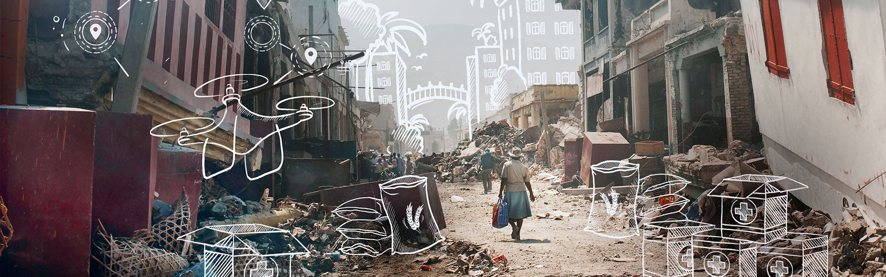
Why do we need this new technology?

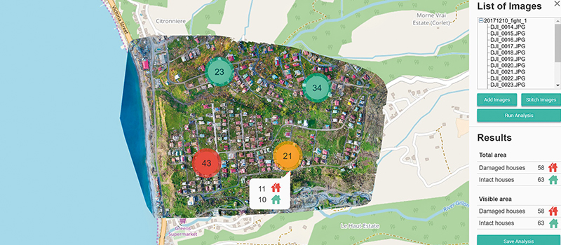
Following natural disasters such as earthquakes, tsunamis, and hurricanes, there is tremendous time pressure to distribute aid materials in disaster-stricken regions so they reach victims there in time. The first aid organizations typically reach the scene in just hours. But when they get there, they find an extremely confusing situation, with heavily damaged roads and settlements and people fleeing from one area to another. Emergency coordinators currently use satellite images to gauge the extent of the disaster, the number of people who need help, and potential search and rescue routes. But precious time passes before the images of the hard-hit areas are available and have been analyzed.

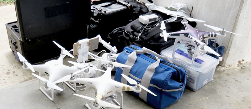
To meet this need, the United Nations World Food Program (WFP) deploys drones to take aerial photos of the region affected by the disaster. Aid workers are then left to sift through hundreds of individual images to get an overview. This is a time-consuming and staff-intensive process, which is why it can only be done on a spot check basis, with incomplete coverage based on people’s “gut instincts”. Unintended outcomes can include problems like aid materials being inadvertently sent to almost uninhabited areas while people elsewhere wait in vain for life-saving assistance.

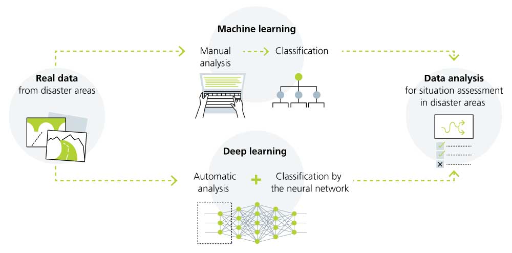
Software supported by artificial intelligence (AI) that assembles and analyzes the images automatically and in real time, even without internet access, would accelerate the process of providing humanitarian assistance while also ensuring that the aid gets to where it is needed most.

© Fraunhofer ITWM
Drones quickly supply image data on the scale of the disaster.

Who will benefit from the new technology?

Using a software program that analyzes drone images in real time, teams of workers from aid organizations can identify specific areas as priorities for intervention, map out reliable routes in the disaster-stricken region for truck convoys, and get the process of distributing aid started faster. Fewer of the shipments would come to nothing, and urgently needed aid would reach disaster victims faster. Analyses of image data could also help with planning and organizing the efforts to rebuild and accelerate these activities.

© Fraunhofer ITWM
Screenshot of a prototype of the image recognition software from Fraunhofer ITWM.

How does the new solution work?

The basis for the fast, fully automated analysis of drone images is the combination of image processing and deep learning algorithms that the researchers at Fraunhofer ITWM are developing. Deep learning is a discipline of machine learning that relies on artificial neural networks to analyze large amounts of data. It is modeled on biological neural networks, like those found in the human brain.

For the artificial intelligence (AI) to learn independently, the researchers have to feed data into the software as the first step. To do this, they use satellite images from past WFP activities and add information on relevant features such as buildings and roads. This process is called annotation and modeling. After the preliminary work is complete, the raw data is then fed into the neural network.

Then, once the data has been prepared, training can get under way under real-world conditions in disaster-stricken areas. The software uses the annotated data and deep learning algorithms to autonomously gather and analyze newly collected image data. A multi-layer structure and iterative linking of content allows deep learning systems to learn data for themselves. In contrast to traditional methods of machine learning, this approach eliminates the laborious and time-consuming process of manually modeling data. It also means the software gets better and better over time. The researchers supervise the software during the training process until it is good enough to provide reliable and valuable help to aid workers in disaster situations.

Project EDDA
© Illustration: Fraunhofer, Alexandra Gabler
EDDA combines machine learning and deep learning.

What makes the project unique?

Collaboration with the United Nations World Food Program (WFP) plays a central role throughout the development process. In many cases, the large data records that are needed to use deep learning are simply unavailable. In the EDDA project, researchers can rely on real-world data collected by the WFP as part of its activities. Collaboration with the WFP is also a crucial part of training the neural network, which takes place directly in the hard-hit areas. This keeps the software aligned as much as possible toward practical applications, as aid workers can test it in the disaster zones. This type of practical testing allows for maximum user friendliness during development while also training the neural network.

To quickly get humanitarian assistance to where it is needed, aerial images must be analyzed as quickly as possible and with maximum reliability. The image recognition software from Fraunhofer ITWM is intended to analyze several tens of thousands of drone images within three hours at most and determine the number and condition of buildings and identify routes that can be used to transport the aid materials with at least 80 percent certainty. It can be used on standard commercially available notebook computers, and it works even without internet access, as the infrastructure is often heavily damaged in disaster zones. The Fraunhofer ITWM image recognition software is provided to aid organizations for non-commercial use free of charge and without licensing.

Projektschritte
© Fraunhofer, Alexandra Gabler
Steps in the EDDA project.

Why is the Fraunhofer Future Foundation supporting this project?

Every year, tens of thousands of people face starvation or even death in the wake of natural disasters because humanitarian aid in the form of medications or food does not reach them in time. The Fraunhofer Future Foundation is supporting the development of the EDDA image recognition software, which is driven by deep learning, to give aid coordinators a way to make fast, sound decisions in crisis-hit regions. The results of their analysis can be used to save lives and accelerate efforts to rebuild stable infrastructure.

© iStock
Truck convoys of the United Nations World Food Programme (WFP) deliver humanitarian aid to the suffering population.

More projects on the topic "Resilience and infrastructure"


NexusHub

The NexusHub project combines water-conserving crop cultivation and climate-friendly energy supply. The interaction of multiple robust technologies unlocks development prospects for less-developed regions.


WiBACK

4 billion people still do not have access to the internet. WiBACK (Wireless Backhaul) connects people who are excluded from digital participation with the rest of the world — and gives them long-term access to the education and healthcare systems.


CycloPlasma

Millions of buildings are potentially contaminated with carcinogenic neurotoxins due to wood preservatives from the 1970s and 1980s. CycloPlasma technology makes it possible to remove this harmful substances.